Mosquito Fire in Placer, El Dorado: Homes burn, residents flee as flames surge over American River
READ MORE
Mosquito Fire
Click the arrow below for more coverage of the Mosquito Fire burning in Northern California.
Expand All
Saturday’s update: Mosquito Fire has burned nearly 34,000 acres, smoke conditions may improve
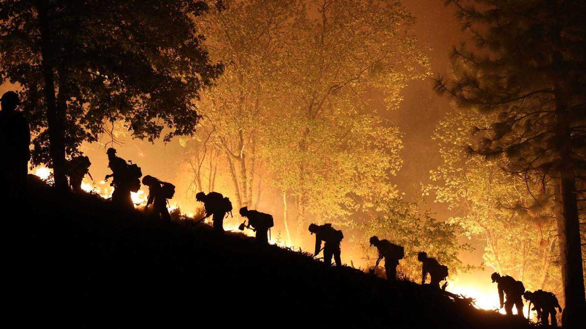
Georgetown, Volcanoville and Bottle Hill were ordered to immediately evacuate Thursday afternoon as the Mosquito Fire accelerated its destruction by jumping the Middle Fork of the American River and thrusting south into El Dorado County while continuing to burn near the Placer County community of Foresthill.
The fire had grown to more than 13,000 acres by late Thursday afternoon. At a town hall meeting Thursday night in Auburn, Cal Fire officials said the wildfire was threatening 3,600 homes.
Evacuation orders have been in place since Wednesday morning for the Volcanoville area and Tunnel Hill areas of El Dorado County, and were expanded Thursday afternoon to include the Quintette, Bald Mountain, Grey Eagle Hill and Battle Hill areas.
The wildfire on Thursday made a 5,000 acre run south into El Dorado County. Cal Fire Amador-El Dorado Unit Chief Mike Blankenheim said the fire moved “a hard uphill run” into Volcanoville before the wind pushed the flames east.
Structures burn in Volcanoville
“As it stands right now, Volcanoville has definitely been impacted. We did have some structures there destroyed in there, for sure,” Blankenheim said Thursday night.
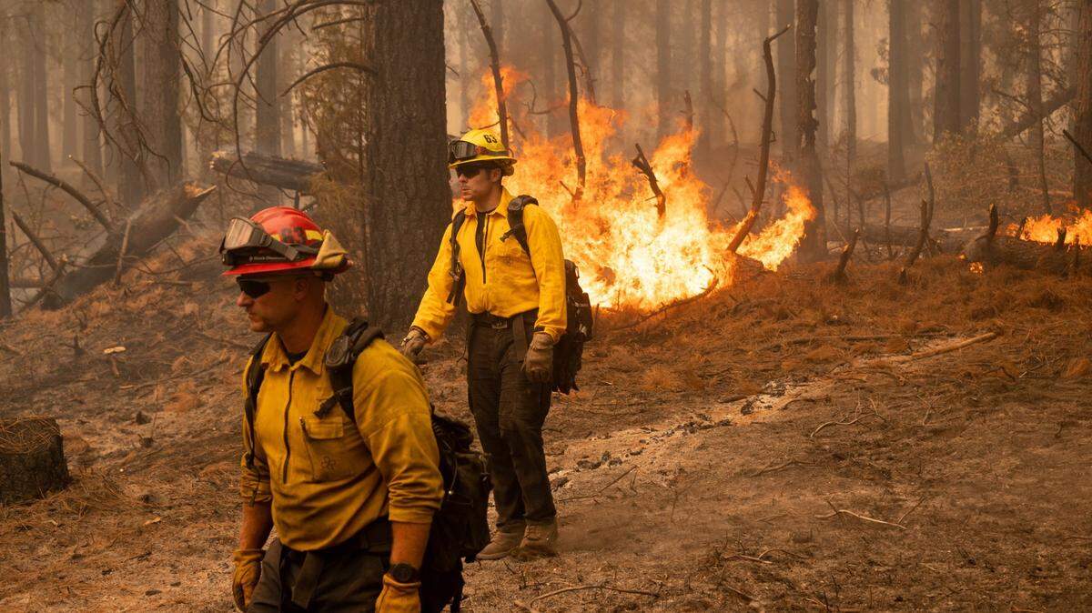
There were a lot of firefighting resources protecting homes and other buildings Thursday in Foresthill. Cal Fire officials said the fire was getting close to Foresthill, but the flames had not outflanked them there.
Cal Fire Nevada-Yuba-Placer Unit Chief Brian Estes, who was in Foresthill Thursday, said firefighters were doing “everything they possibly can” to protect that town.
“I will tell you from the bottom of my heart, and you can take this to the bank, our priorities always will remain the protection of life and property,” Estes said at the town hall meeting. “And our commitment to the community of Foresthill is paramount.”
The mandatory evacuations were issued just before 4 p.m. for all of Georgetown, a town of close to 3,000 people about 15 miles north of Placerville. The El Dorado Sheriff’s Office said the following areas needed to evacuate immediately:
- In Georgetown: East of Greenwood Road, south of the county line and north of Meadow Brooke Road.
- In Bottle Hill: Use westbound Wentworth Springs Road toward Georgetown for areas east of Breedlove Road, including both sides of Wentworth Springs Road; Breedlove Road west of Stumpy Meadows Lake.
- In Volcanoville: North of Wentworth Springs, east of Otter Creek, south of the county line and east of Tunnel Hill Road.
Evacuated four times — ‘this is the worst of it’
Josh Manzer and his girlfriend, Arianna, driving in a convoy from their Volcanoville home Thursday after 8 p.m., headed up Wentworth Springs Road toward Highway 50 hoping to find a place to camp for the night.
The couple has lived on Christmas Tree Lane in Volcanoville for 10 years. They worried they had lost their home after evacuating around 2:30 with their five dogs and stopping to pick up a trailer they own.
“We just picked up our trailer right now,”Manzer said from the cab of his pickup truck, which was towing his trailer as his girlfriend drove behind in a sedan. “Our house is probably gone.
“Volcanoville’s on fire.”
Manzer said initially sheriff’s officials wouldn’t let them get into another piece of property where the trailer was stored, but that he was able to convince them.
“We’re like, ‘if our house goes up we can live in our trailer,’” he said. “We were just able to get our trailer. But we left our home.”
The couple said they had plenty of notice and began packing around 10 a.m.
“We started packing this morning at around 10, because this is the fourth time we’ve been evacuated up here, but this is the worst of it. We’re headed with the dogs and trailer, we’re going to hit (Highway) 50 and probably camp at one of the spots up there.”
Manzer said he had his five dogs — a German shepherd, a husky mix and “a couple of mutts” — and knew they had to leave once they realized the size of the blaze.
“Once they said it jumped the ridge, there was tons of smoke,” he said. “We didn’t leave for the King Fire, but for this one we knew we had to go.”
Sheriff’s officials ordered evacuations of Georgetown and nearby areas Thursday afternoon after the fire jumped the American River Canyon into El Dorado County, but by 10 p.m. the blaze still appeared to be miles from Georgetown and Volcanoville, where some structures had been burned, but appeared largely intact.
The Otter Creek School had been spared, with the fire burning up to a ridgeline near its basketball court and playground, and most of the flames there Thursday were spot fires blazing from fallen trees.
Evacuations grow in El Dorado County
Evacuation warnings were extended to the Cool and Pilot Hill areas along Highway 49 at 5 p.m., as well as the Garden Valley area to the east and further east in the area of Slate Mountain including Swansboro and Stumpy Meadows, the El Dorado County Sheriff’s Office said.
El Dorado County opened an overnight emergency shelter for Mosquito Fire evacuees at the Cameron Park Community Services District at 2502 Country Club Drive in Cameron Park. Overnight shelter, meals, showers and limited health services will be provided. Animals in crates or carriers will be accepted there with parking available for trailers.
Roughly 250 people live in Volcanoville and another 100 in Quintette. To evacuate Volcanoville, residents had to come down a paved one-lane road, and at one point had to cross a narrow one-lane bridge to get to Wentworth Springs Road. As the fire roared during the day’s high temperatures, there was a steady stream of vehicles, RVs and trucks pulling horse trailers on Highway 193 toward Highway 49.
Outside of Georgetown, about seven miles east of Volcanoville, residents of the Hotchkiss Hill neighborhood were driving out of their hilltop homes. John and Alice Wenger were pulling out in a black Volvo station wagon loaded with belongings after sheriff’s deputies had come by knocking on doors around 4 p.m. telling people to get out.
“We’ve got everything we need out of the home,” John Wenger said, as another neighbor, Stefani Lake, stopped to check her mail.
“The mail’s important,” Lake said as she bundled up her letters and also prepared to flee the hilltop community.
“The dogs are in the back of the car, I’ve got a room for the night, so I’m ready to leave,” Lake said.
Just past the roadblock set up to stop traffic from entering Volcanoville, a retired Sacramento Fire Department captain was nonchalantly checking his mail before he left because of the evacuation.
The 61-year-old former firefighter, sporting a Sac Fire hat and shorts, gave his name only as “Mike” and said residents had gotten plenty of warning to get their belongings and get ready to leave.
“This area has not been hit with a big fire for 60 years,” he said, as his dog Lucy wandered around at his feet.
Mike said his biggest concern was the undergrowth in the area, which after a solid week of 100-plus degree temperatures is bone dry.
“All you need is a wind change, and then poof,” he said, adding that he had lived in the area for 32 years. “We’ve just let the undergrowth go for so long.”
But he added that he had been able to follow his pre-set emergency plan and load his vital belongings into his motor home on Thursday afternoon and had ample time to start packing non-essential items while his son, a Cal Fire firefighter, waited at home.
Yellow crime scene tape marked driveways along the highway, where sheriffs deputies have made certain that people evacuated.
A temporary evacuation point reopened Thursday afternoon at Cool Community Church, 863 Cave Valley Road, Cool, after closing Wednesday evening, the El Dorado County Sheriff’s Office said. Evacuees can gather at the center along with domestic animals, except for birds, due to the risk of spreading avian flu.
Placer County communities still under threat
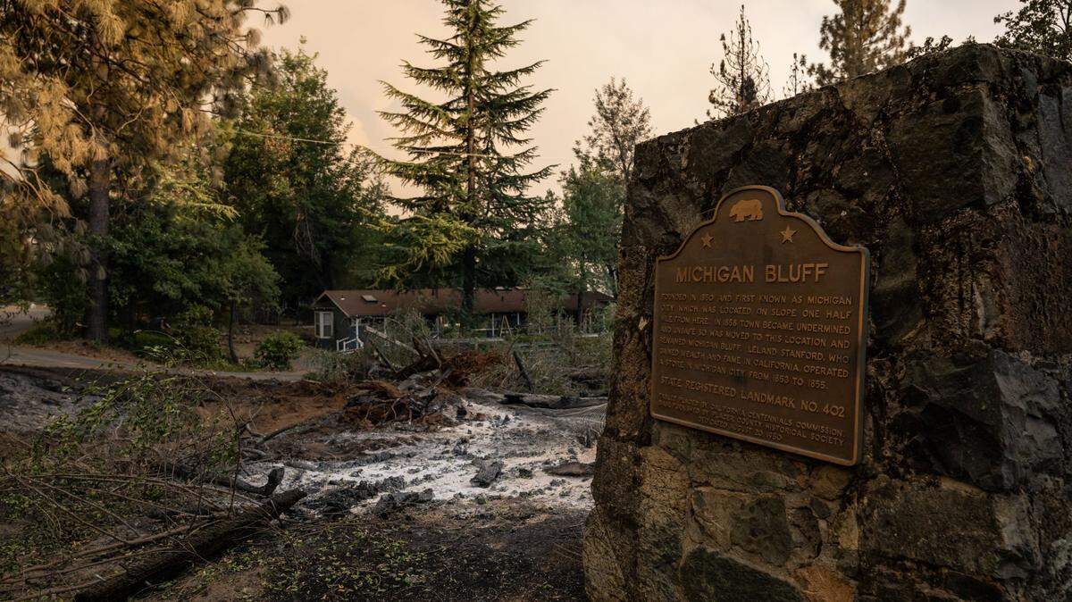
All of Foresthill, a town of 1,500 people, and nearby communities including Michigan Bluff have been under mandatory evacuation orders from the Placer County Sheriff’s Office since midday Wednesday. Todd Valley, just west of Foresthill, was ordered to evacuate just before 3:30 p.m. Thursday, according to the Foresthill Fire Protection District.
Placer County declared a local emergency for the Mosquito Fire at 1:30 p.m. Thursday. California Gov. Gavin Newsom on Thursday evening declared a state of emergency for El Dorado and Placer counties due to the Mosquito Fire. The governor also declared a state of emergency for Fairview Fire in Riverside County.
Aircraft mapped the Mosquito Fire as of 4:45 p.m. at 13,705 acres, more than 21 square miles. At 1:30 p.m., the fire was mapped at 8,625 acres, or more than 13 square miles, up from 6,870 acres in a 7 a.m. update from Cal Fire and the Forest Service. It is 0% contained.
The fire “is continuing to chunk west toward Foresthill, as well as burn actively to the northeast” in addition to spreading south across the river, Cal Fire Nevada-Yuba-Placer operations section chief Nolan Hale said in an afternoon video briefing.
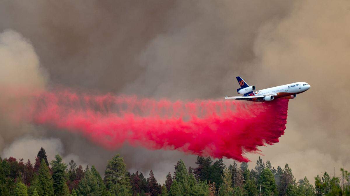
By 10 p.m., much of the fire activity remained on the Placer side, aided by a parade of aerial drops as planes were given the “no diversion” order to zero in on the rapacious flames, which grew by thousands of acres Wednesday, sending smoke billowing across large swaths of Northern California.
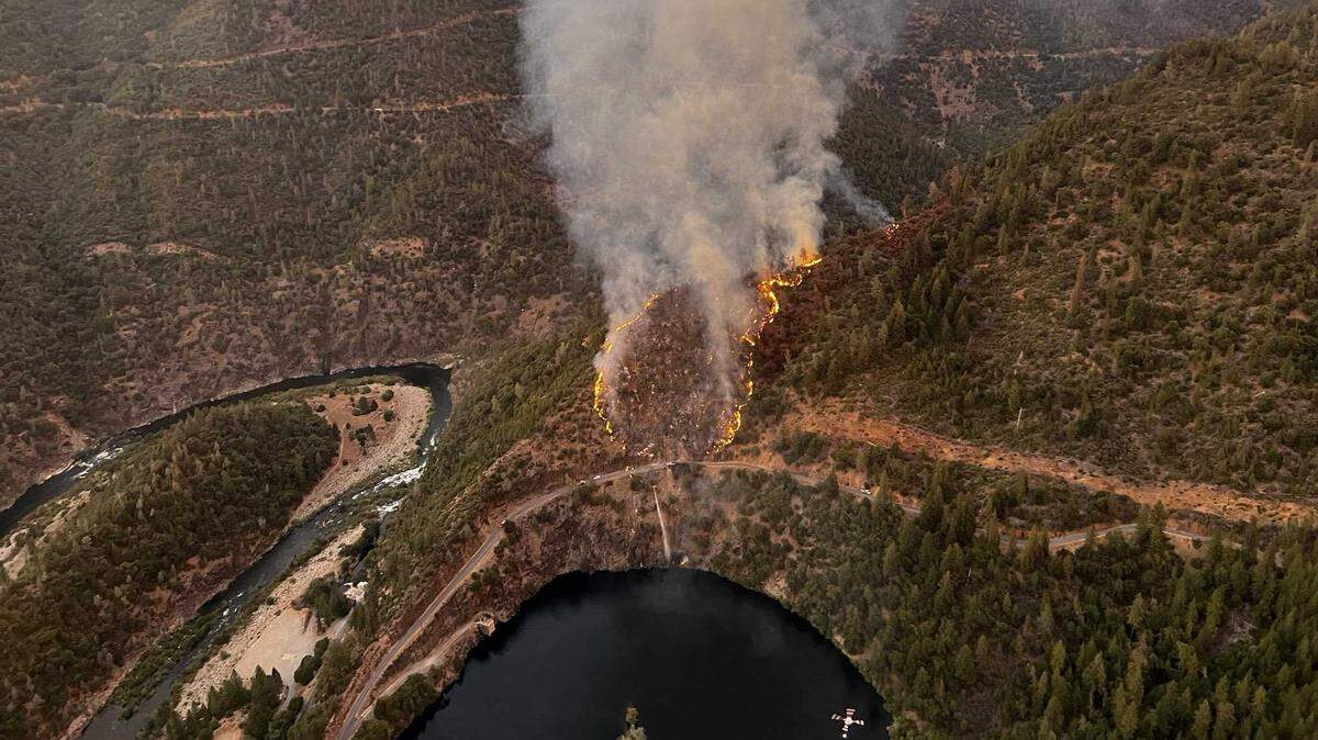
The Mosquito Fire continues to threat roughly 1,000 structures including critical infrastructure, Cal Fire’s Nevada-Yuba-Placer unit said. Infrastructure at risk included the Sugar Pine Dam, Placer County Water Agency’s pump station and dam, large power lines, the Ralston hydroelectric powerhouse and cellphone towers.
The wildfire, one of several major blazes burning amid a record-smashing September heat wave that has descended on drought-ridden California, is burning in critically dry brush and timber, fire officials said.
The blaze displayed “extreme” behavior all day Wednesday and more than quadrupled in size over the course of the day, fire authorities said in incident reports, after igniting Tuesday evening in steep terrain near the Oxbow Reservoir at Tahoe National Forest, quickly spreading northwest toward Foresthill.
Foresthill, a town of roughly 1,500 people, was ordered by the Placer County Sheriff’s Office to evacuate midday Wednesday, along with immediately surrounding communities in Placer County. Parts of Volcanoville in El Dorado County were also placed under mandatory evacuation orders.
An evacuation center remains open at Bell Road Baptist Church, 77 Bell Road, Auburn.
PG&E says equipment roped off by fire officials
Pacific Gas and Electric Co. in a filing to state regulators Thursday morning said “electrical activity occurred close in time to the report time of the fire” on one of its transmission poles near Oxbow Reservoir.
“The (Forest Service) has placed caution tape around the base of a PG&E transmission pole (60Kv),” PG&E officials wrote in a filing to the California Public Utilities Commission. “Thus far, PG&E has observed no damage or abnormal conditions to the pole or our facilities near OxBow Reservoir, has not observed down conductor in the area or any vegetation related issues.”
The utility company, which has been ruled criminally responsible for sparking the 2018 Camp Fire in Paradise and whose equipment was determined as the cause of last year’s nearly million-acre Dixie Fire in the Sierra Nevada foothills, wrote that it submitted Thursday’s filing “out of an abundance of caution,” as the electrical incident “involves an event that may meet the property damage reporting requirements.”
The Mosquito Fire’s cause remains under investigation by Cal Fire and the Forest Service.
Damage in Michigan Bluff
Crews are “aware of structure damage in the Michigan Bluff area” near Foresthill, according to Cal Fire’s Thursday morning incident report, but the extent of damage was not immediately clear. Damage inspections have not been conducted due to unsafe conditions, Cal Fire said.
About 1,700 personnel are assigned to the fire, Cal Fire said.
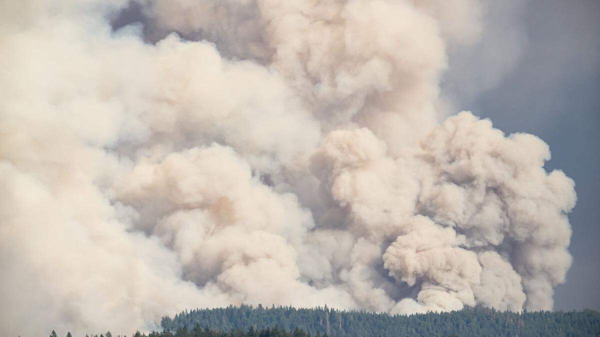
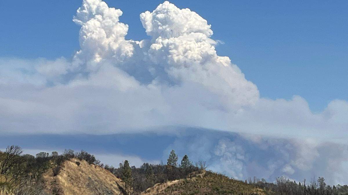
The Mosquito Fire throughout most of Wednesday produced a pyrocumulus cloud — a towering smoke plume similar in appearance to a volcanic explosion. The plume could be seen from the Sacramento area, other neighboring Northern California counties and parts of western Nevada.
By Thursday morning, hazy skies settled over Sacramento as winds blew smoke into the region, but more pyrocumulus smoke emerged by early afternoon as the fire began its run into El Dorado County.
Air pollution was recorded at “hazardous” levels above AQI 200 as of 9 a.m. in parts of Placer, El Dorado and Sacramento counties, including Folsom, El Dorado Hills, Granite Bay, Orangevale, El Dorado Hills and Cameron Park, according to an online air quality map from the Environmental Protection Agency. Pollution reached “very unhealthy” levels near Auburn, Newcastle and Penryn, and “unhealthy” levels near Roseville, Carmichael, Citrus Heights and Rancho Cordova.
Air quality remained in the “moderate” level within Sacramento city limits, according to the map.
Heavy smoke was also expected to blow east toward Lake Tahoe, according to the National Weather Service.
The Forest Service on Wednesday evening announced that a large portion of Tahoe National Forest, including the French Meadows Reservoir and the popular Western States Trail, will be closed to the public through at least the end of 2022.
The closed trail is the site of the annual Western States 100-Mile Endurance Run, which starts in Olympic Valley and ends in Auburn. The race was run in June this year.
Barnes Fire in Modoc County
A blaze that sparked Wednesday in Modoc County, the Barnes Fire grew to 1,621 acres.
The Modoc County Sheriff’s Office issued evacuation warnings for the communities of Willow Ranch and Fort Bidwell, which remained in place as of Thursday morning.
The fire grew minimally overnight but fire activity is expected to increase due to worsening fire weather conditions, Modoc National Forest officials said in a Thursday morning update.
Coyote Fire in Siskiyou County
A new vegetation fire sparked Wednesday in Siskiyou County, Cal Fire said, with forward progress stopped at just shy of 300 acres.
The Coyote Fire was burning along Coyote Ridge, about 10 miles southwest of the town of the city of Dorris, Cal Fire’s Siskiyou unit said Thursday morning.
All evacuation warnings have been lifted on the fire, which was reported at 297 acres with 20% containment.
Mill and Mountain fires in Siskiyou County
The Mill Fire, which killed two people and leveled dozens of homes in its initial explosive run last week near Weed, held at 3,935 acres as of Thursday evening with a slight increase to 80% containment.
Crews have completed damage assessment and determined that 92 buildings were destroyed with 17 others damaged. Two women ages 73 and 66 died, authorities said, and three other civilians were injured.
Mandatory evacuation orders remained in place for parts of the Lake Shastina community, where homes were damaged and destroyed. Evacuation orders within the city of Weed have been lifted or downgraded to warnings.
Roseburg Forest Products, which operates a mill in Weed, acknowledged Wednesday it was investigating whether a malfunctioning sprinkler system allowed smoldering ash from an on-site power plant to ignite the Mill Fire.
Cal Fire’s Siskiyou unit said the Mountain Fire remained at 11,690 acres with an increase to 55% containment Thursday evening. Minimal fire activity was observed overnight, but gusts up to 25 mph are expected to continue Thursday. Two structures were destroyed, and about a dozen residents remained under evacuation orders.
Fairview Fire in Riverside County
The deadly Fairview Fire in Southern California grew intensely Wednesday, with Cal Fire reporting acreage soaring from 9,846 acres at 7 p.m. to 18,657 acres by 7 a.m. Thursday.
The fire ignited Monday and is burning near Hemet, where mandatory evacuations remain in place. It was threatening about 2,500 structures as of Thursday morning.
Cal Fire said the fire remained active Wednesday on its eastern, southern and northern flanks.
Two civilians have died and another has been injured in the Fairview Fire.
Like Placer County’s Mosquito Fire, the Fairview Fire created a large pyrocumulus cloud Wednesday.
This story was originally published September 8, 2022 at 8:52 AM with the headline "Mosquito Fire in Placer, El Dorado: Homes burn, residents flee as flames surge over American River."